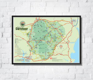
This lovely full colour A3 Dartmoor map, lists the Trig Points on Dartmoor, perfect for wall decor or to tick them off as you visit them. The trig points have been listed in order of altitude.
Trigpoints are the common name for “triangulation pillars”. Usually/typically concrete pillars, about 4′ tall, which were used by the Ordnance Survey in order to determine the exact shape of the country. They are generally located on the highest bit of ground in the area, so that there is a direct line of sight from one to the next. By sitting a theodolite (an accurate protractor built into a telescope) on the top of the pillar, accurate angles between pairs of nearby trigpoints could be measured. This process is called “triangulation”.
Prints are on smooth A3 card.
Please note that this is an artistic interpretation of trig points and certain filters have been applied to design the print. The trig points are either pillars, concrete rings or intersected stations and include all conditions other than destroyed.
Price includes postage by Royal Mail to anywhere in the UK. To post outside of the UK please email for details simon@visitdartmoor.co.uk